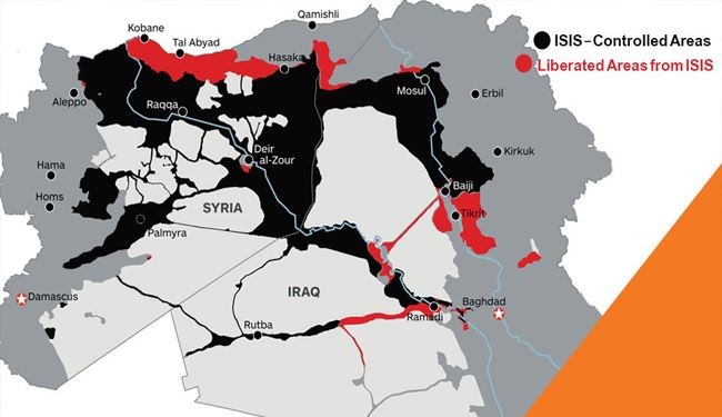
This info-graphic shows so-called Islamic State (ISIS, ISIL or Daesh) geography. Until the beginning of 2015 ISIS had occupied more than 40% of Iraqi land which included Nineveh, Al- Anbar, Saladin, and many parts of Diyala Province, and some areas in Kirkuk. The ISIS controlled areas in Syria in the first half of 2015 included 50% of the country. But according to the reports by Western countries, ISIS has lost 14 to 30 percent of areas that were under its control in Iraq and Syria, Al-Alam News Network reports.
string(370) "[{"id":"1761828","sort":"3490701","contenttypeid":"21","pic":"/2015/11/21/alalam_635837129158786394_25f_4x3.jpg","title":"Infographic, Who Supports ISIS in “The Dirty War on Syria”"} ,{"id":"1787325","sort":"3490700","contenttypeid":"21","pic":"/2016/02/08/alalam_635905308814955798_25f_4x3.jpg","title":"INFOGRAPHIC: CREATION AND INTELLECTUAL FOUNDATION OF ISIS"} ]"